The Xizang Autonomous Region is called Tibet, is located our country north west on the Qinghai-Tibet Plain, east near Sichuan, north meets Xinjiang, Qinghai, west is connected with Kashmir, southeast is Yunnan Province, south with Nepal, the Sikkim, Bhutan, India, Burma adjoins.
Tibet is in has "name of on the roof of the world" Qinghai-Tibet Plain, the topography by northwest inclines to the southeast, the terrain complex is diverse. Above entire area average elevation 4,000 meters. In the terrain may divide north Tibet east the plateau, Tibet the high mountain valley, the South of Tibet valley with the Himalayas. The main sierra has Kunlun Mountain, Tanghla mountain, the Nyaniqentanglha, the Himalaya Mountains and so on, is located in the Chinese-Nepali frontier Mount Everest, the elevation 8848.6 meters, is the world high point. The main rivers have Yarlung Zangbo River, Lanchan River, Yangtze River, Nujiang and so on, and has the nam lake and so on more than 1,500 high land moors.
Local as a result of the terrain, the landform and the upper air circulation influence, the climate complex is diverse. Besides southeast partial areas quite warm moist, other majorities belong to the plateau climate lowly, the temperature, the diurnal temperature difference big, the precipitation few, thin air, the sunshine is sufficient, annual mean temperature -3 ℃ - 12 ℃, annual mean precipitation 60 - 1,000 millimeters.
The Xizang Autonomous Region total population 2.67 million, take Tibetan nationality as a main body. Moreover also has the Chinese, returns to, Pakistan, Naxi, anger nationality and so on 门巴, 珞.In 2002 population birth rate 18.83 ‰, mortality rate 6.07 ‰, natural rate of growth 12.76 ‰. To 2002 底本 the boundary employment personnel is 1.29 million people.
The Xizang Autonomous Region area more than 1.2 million square kilometers, the entire area governs 6 local, 1 place level cities, 1 municipal district, 1 county level city, 71 counties, altogether includes 140 towns, 541 townships (8 ethnic townships), 8 subdistrict offices. The autonomous region capital is Lhasa.
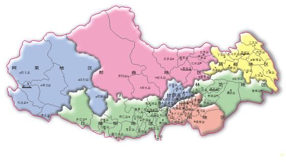
Xizang Autonomous Region politics area chart
Tibet ancient for Qiang, the Rung place, the Tang Dynasty is the Turfan place, in 13 centuries the leaf, Yuan Dynasty enters and is stationed in Tibet, from this time on Tibet brings into line with the Chinese domain, a Ming Dynasty senate Yuan old system, after clear minute health (former Tibet), Tibet (Tibet), 喀 wooden (Kang), Ali four, always calls Tibet. In 1951 the peaceful liberation, in 1965 built the Xizang Autonomous Region.
The Xizang Autonomous Region as a result of the terrain weather effect, the Tibet multi- planters cold resistant plant, the main crops is had the Tibetan barley, the wheat, the corn, the pea, the broad bean, the potato and so on, southeast Tibet also produces the paddy rice, the sorghum, the tea and so on. Tibet is our country one of five prairies pastoral areas, the natural pasture area occupies head of the national, the animal husbandry occupies the important status, has the yak, the sheep, the horse and so on. In 2002 per capital GDP 5,983 Yuan/people. Grain total output 980,000 tons, milk product 240,000 tons. After the liberation the industrial development was quicker, completes one batch lightly to spin, industry class and so on food, building materials, forest, electric power, metal mining, machine manufacture, leather, drugs manufacture. In 2002local financial revenue 730 million Yuan, expenditure 13.8 billion Yuan.The cities inhabitant average per person may control the income is 8,079 Yuan. Fixed asset investment 10.9 billion Yuan.
Before the liberation, Tibet does not have the road, already completed Sichuan and Tibet, Xinjiang-Tibetan, Qinghai and Xizang, Yunnan Tibet province and so on and so on highway connection Sichuan, Xinjiang, Qinghai and Yunnan, places such as East Asia, Nyalam, date earth has leads to South Asia Zhu Guo's the international road, in the autonomous region the federal highway and the local highway interweaves the net. Yarlung Zangbo River, Lhasa River, year Chu He, Nepali ocean tune and so on passable 皮筏 and wooden boat. Lhasa and Qamdo all have the civilian airliner rise and fall, passable toward places such as Beijing, Chengdu, Chongqing, Katmandu.
Tibet is goes sightseeing the best destination
which the traveling, the science inspection, the exploration goes on a
pilgrimage. Has included "World Inheritance Name list" Potala
Palace, resplendent in gold and jade green, had demonstrated the
Tibetan nationality ancient construction essence, is the Buddhism Holy
Land; Is "the Earth third level of" Mount Everest toweringly
raises by the reputation, the palatial grand glacier broad cloth, "the
Mount Everest water-dunnel" element has under the "ice name of the
palace"; Also has the elegant 砻 river scenery scenic spot
area, the saint mountain and the sacred lake, grips local the assorted
logical sequence cloth temple and Lhasa's Jokhang Monastery, the small
illustrious temple and Norbu Lingka, Zhaibung Monastery, Sera
Monastery, the Tibetan King grave and so on all is the famous
traveling place.
More >>